Summary of the Project:
The project is designed to enhance the 7u8x0 ‘Geographic Modelling of the Built Environment’ course, a 5 ECTS elective for bachelor students starting in Quartile 4. The course integrates Geographic Information Systems (GIS) with two- and three-dimensional spatial data collection using devices like Smartphone Apps, GPS trackers, and Drones. With drones becoming increasingly popular for measuring and visualizing building volumes, the project addresses the current lack of knowledge and specific tutorials on drone data collection for bachelor students. This is particularly beneficial for Urban Planning, Transportation Planning, Real Estate Management, and other Built Environment disciplines.
Aim of the Project
The goal of the project is to develop a set of tutorials that helps students conduct the exercises through self-study and learns teachers/students to work with the involved hardware (drone) and software (photogrammetry and GIS) systems. As a result, the project will provide a set of tutorials dealing with the use of a drone (including setting up, controlling, and using) and a guide to collect and transfer the data from this device into GIS.
The project will undergo testing with students of the Geographic Modelling course, followed by evaluations. The aim is to eventually make these resources accessible to all students needing 3D data for their projects, ensuring a sustained and valuable addition to their learning experience.
Results and learnings
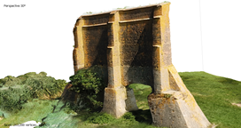
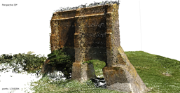
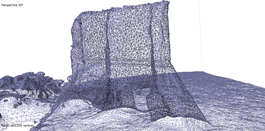
This project developed and implemented tutorials for students and instructors on using drones for spatial data collection. These include (i) step-by-step video and text guides for drone setup, operation, data collection, integration with photogrammetry and Geographic Information Systems (GIS), and (ii) case studies with pre-collected drone data from specific areas. The resources enable students to independently apply 3D spatial data collection methods in fields like Urban Planning, Transportation Planning, and Real Estate Management. The tutorials are openly accessible at:
The tutorials were tested with a small group of students, whose feedback highlighted their effectiveness in providing hands-on experience with advanced tools, enhancing analytical capabilities, and a deeper understanding of 3D spatial modeling. However, changing regulations of drone flights since the start of this project makes it challenging to collect data at any instance.
Beyond education, the project established a valuable resource for broader academic use, including supporting emerging digital twin research. The openly accessible tutorials and case studies aim to have long-term impact on learning and research, advance the integration of innovative technologies in built environment education and contributing to the field's digital transformation.
For more information, please contact: